The Battle Road Trail. My “happy” place. A place where I reclaimed my health by first only being able to walk just a very small segment and eventually working my way up to walking to Lexington Center and back (14 miles). A place, where surrounded by the natural beauty, I began to heal my broken heart. A place where I walked in a blinding snowstorm, navigated long sheets of ice, watched sunflowers sway in a light summer breeze, observed farmers picking corn on a hot summer day, witnessed the passing of all our New England seasons, and stopped to see the moon rise. A place where I received a phone call, asking me to interview for a position that I was not really looking for, but was the change I didn’t know I needed.
The history of the trail also fascinates me. I think about the quest for freedom that started along this trail. I think about the farmers that mobilized along different sections of the trail that sent the Redcoats scurrying back to Boston. As a mother of a soldier, I think about those young Redcoats who lost their lives far from their mothers and whose deaths are marked along the trail. I think about travelers stopping at the Hartwell Tavern for food and rest. Although the focus of the trail is on what the Battle Road was like in 1775, there is a lot more history of this area than what is presented and in some cases, that other history has been bought out and wiped out. Perhaps it is the wiped out history that is a story waiting to be told.
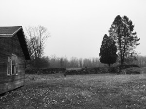
To me, the first mile of the trail, if you start from the Meriam parking area is the prettiest and the most diverse. Starting out from the parking lot, you cross over a small boardwalk and then fields and meadows surround you on both sides. Red winged blackbirds often greet me with their high pitched calls. This trail heads into the woods for a short amount of time before once again popping out surrounded by farmlands; fields of corn on the left and fields of sunflowers on the right. Behind the left field, more fields continue up towards Virginia Road. On the right side of the field, lays a large barn complete with silo, along with other smaller buildings and an old farmhouse that sits on Lexington Road. On the left side of the pasture, there is a small cow barn and at one point, there were some really big cows grazing in this grassy area. Continuing east on the trail, the trail departs from the farmland and heads onto a boardwalk that crosses over wetlands. In the summer, this area is alive with birds and insects who enjoy the cattails that sway in the breeze. After traversing the zigzag of the boardwalk, the trail heads up a small rocky hill before it ends up on a short paved section that is parallel to Lexington Road. And it is on this section of the Battle Road Trail that my story begins.
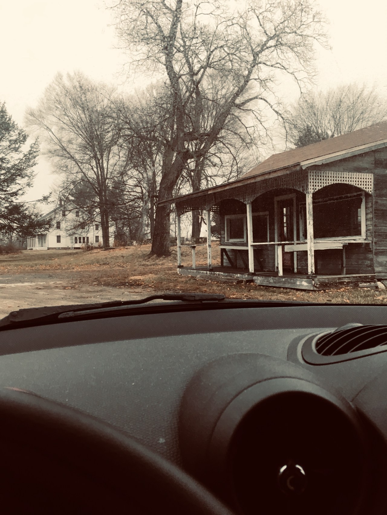
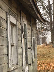
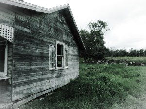
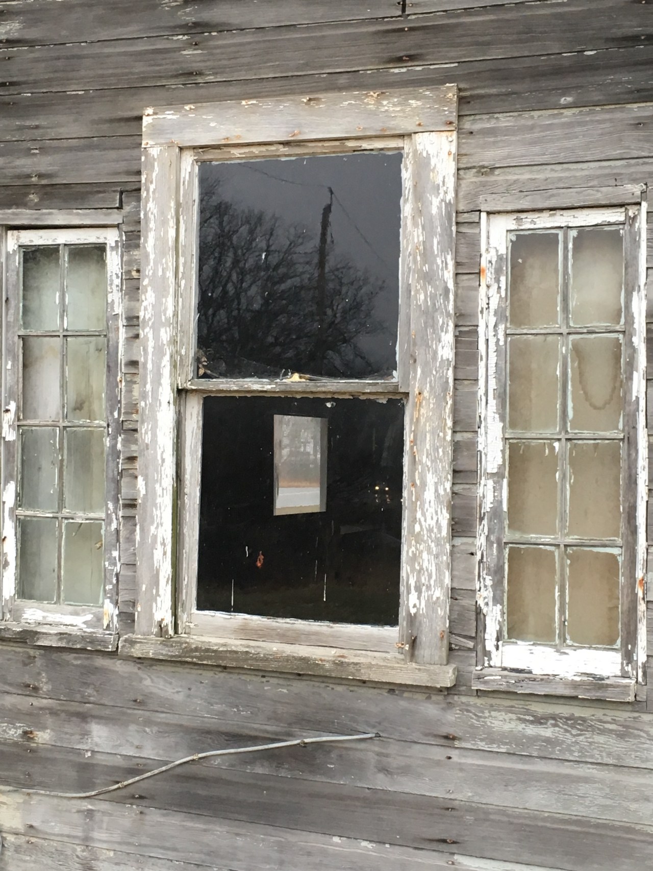
On this section, you pass by a house, a farmstand, and several other buildings that overlook a sloping hill. Several tractors sit next to the out buildings. This farmstand sits at the one mile mark. While heading out for a long walk, it is the end of my warm-up period, where I then need to focus more on the pace I want to maintain for the rest of the walk. On the way back, it means one mile to go, where I will hit a downhill section right after this landmark. I had passed this farm many times, but one day, the empty feeling that it conveyed, spoke to me. On occasional walks, I will stop and take pictures and on that day, the peeling paint and a cracked window with a “Yes We’re Open” sign  on the door of the farmstand, caught my eye. So, I stopped. I remembered a long time ago, visiting this particular farmstand and buying a wreath made out of Oriental Bittersweet. That was the only time I had ever visited that particular farmstand, but I remember a woman who sold me the wreath. But it appeared that even though the sign said “Yes, We’re Open”, that it had been a very long time since anyone had bought anything from this particular farmstand. On later walks by that farmstand, I would notice that the sign had been changed to “Sorry We’re Closed”,
 that there was a sign that warned No Trespassing, Property of the U.S. Government,and on another window was a “Save
  America’s Farms” sticker. The house had a large wraparound porch where I could envision people sitting out on the end of the day, watching the sun set. It made me curious to think about the government clearly now owned the property, but it didn’t really look like they were doing anything with it. This farm, once in business, was clearly vacant and not being used for any purpose.
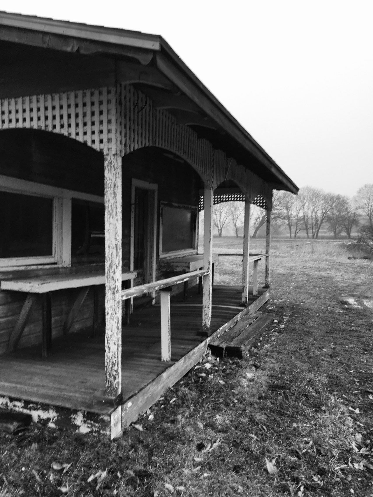
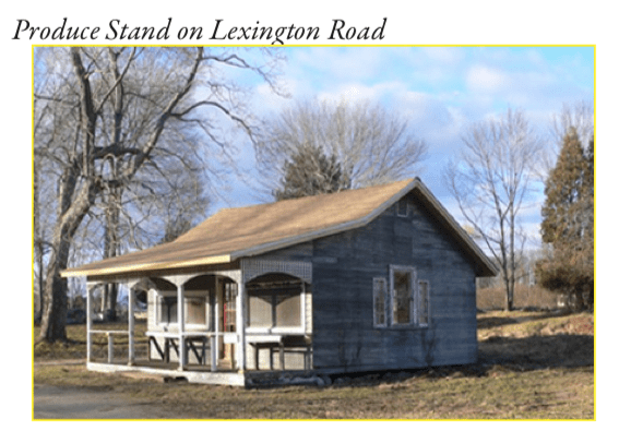
If you are traveling west on Lexington Road (once called Bay Road, since it was the road to the bay) towards Concord Center, you will pass the once working farm (First Root Farm, a Community-Supported Agricultural Farm that was there from 2010 to 2017), and then you will encounter another small farmstand on your right. However, there are no other buildings around this unique farmstand. Even though I had driven by this structure numerous times, after doing more observations of farmstand at the one mile mark, this caught my eye one day and I pulled into the circular driveway to have a deeper look. It was a cloudy day and the fading red door caught my eye. 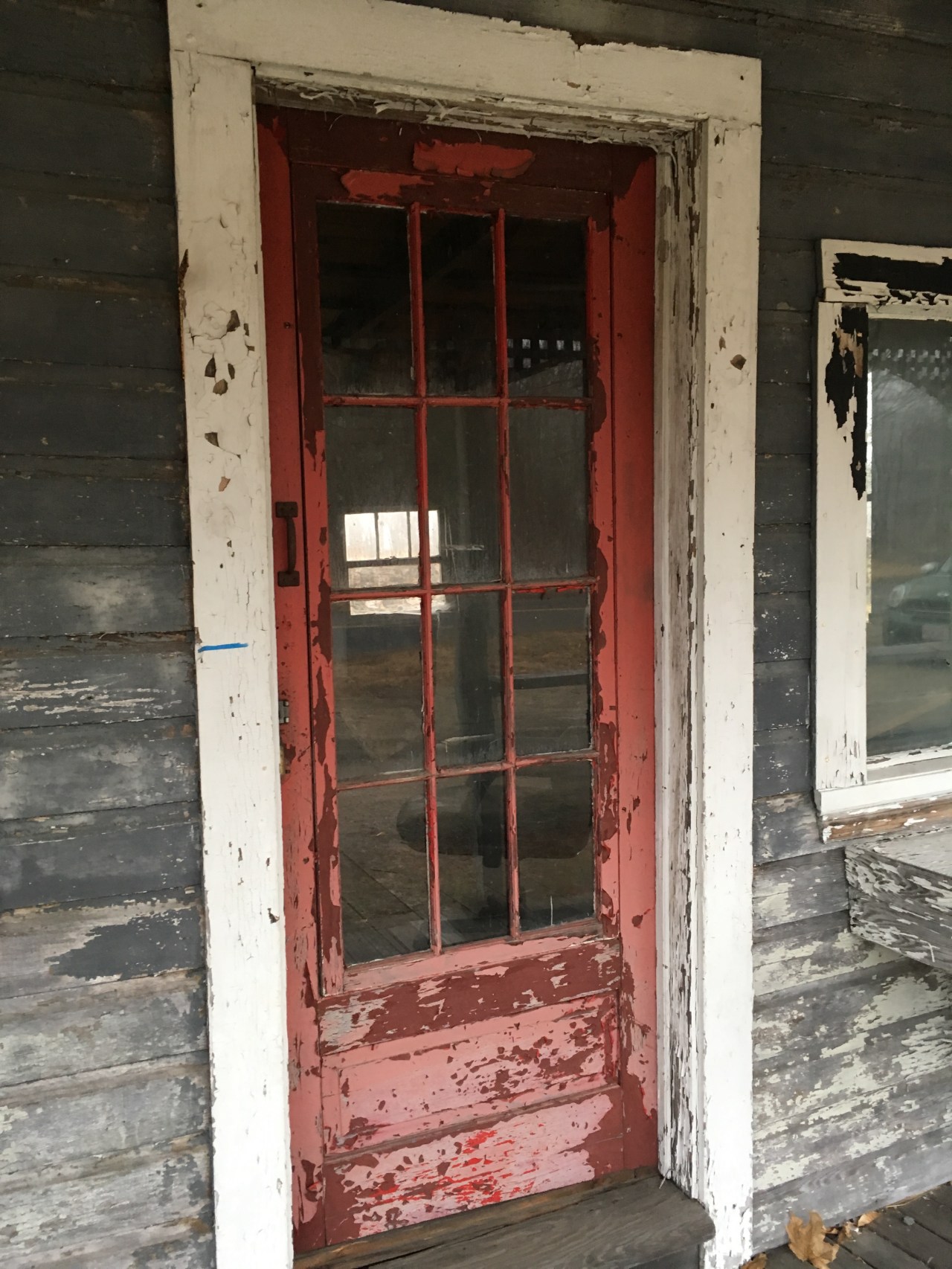 I felt that this building was different – there were no other buildings near it, but it had a grace to it that spoke to me. On the sides of the porch, was a pretty curved lattice that framed a field and a grove of trees behind the field. The front of this farmstand also had large rectangular windows, with benches in front of each window. On one of the benches, sat two framed pictures. For me, it was very strange to see someone’s personal belongings just laying outside. This farmstand had piqued my curiosity so I decided to come back another day to further explore.
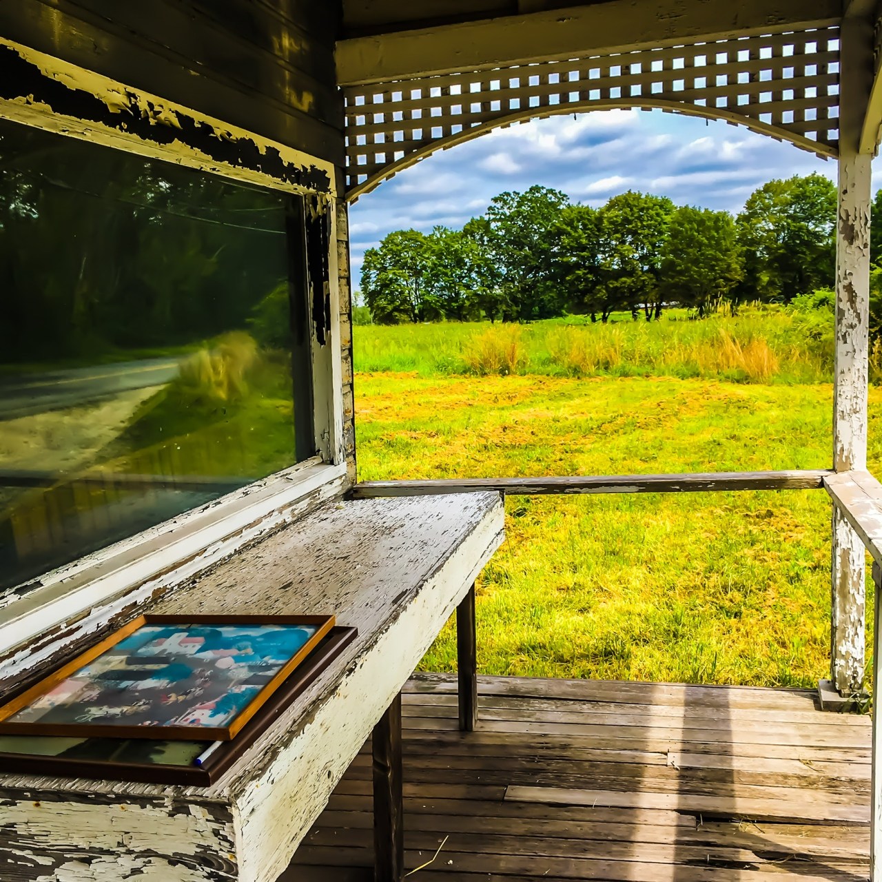
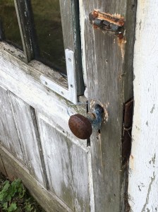
On a hot August afternoon, I parked at Meriam lot and walked to this farmstand to investigate this structure further. Once arriving, I spent time really closely examining the farmstand. For a small structure, it had a lot of windows – the two big ones in the front, one on each side, and two more on the back of the structure. There was the red front door and in the back, a door with nine window panes with a broken lock. Another interesting feature was the remains of a foundation in the back of the farmstand. This foundation was deep and I wondered if it was a barn at one time. There were fields in the back and to the East of the farmstand. I also found several apple trees in the back. Exploring this land only made me more curious about its story. Why was this farmstand still standing where there was nothing else around it? At this point, the theme of my photography was “Abandoned” and this area certainly felt like it was abandoned by someone. But the question was who abandoned it and why did they abandon it?
I spent a lot of time pondering what to do with this series of pictures to present some type of story. Based on a card that I had bought that was a combination of text and pictures, I thought perhaps a type of collage with the pictures and some text was a good thing to do with these pictures. I decided to go onto Google Earth so that I could see this area from a bird’s eye view, which provided me with more information in that there was also a foundation a bit west of the farmstand that I had not seen previously when I walked there. My thinking started shifting from the word “abandoned” to the word “waiting” in that this story was waiting to be found out.
With this shift in mind, I headed down to the Special Collections Room at the Concord Public Library to ask research librarian extraordinaire, Leslie Wilson, if she might have any information about this land. She listened to my questions and said this might be a tricky one. On previous local history projects, I knew of a resource that listed all the historic houses in Concord and I asked Leslie if she had this resource. She walked over to a bookcase and pulled out that resource. I had an approximate address from my Google Earth search. And bingo! Here is what I found out:
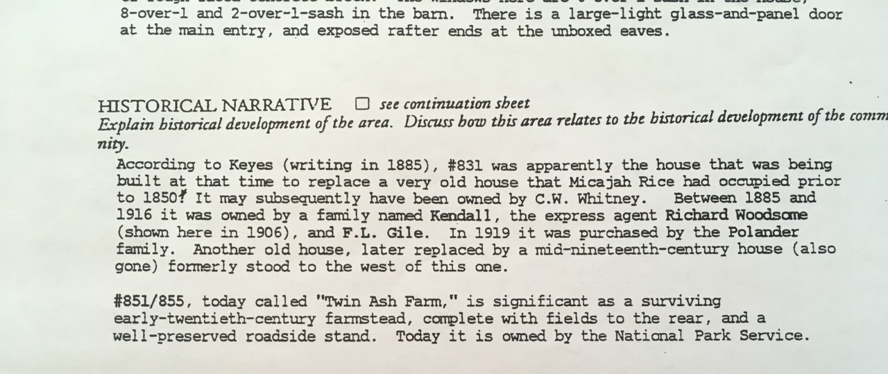
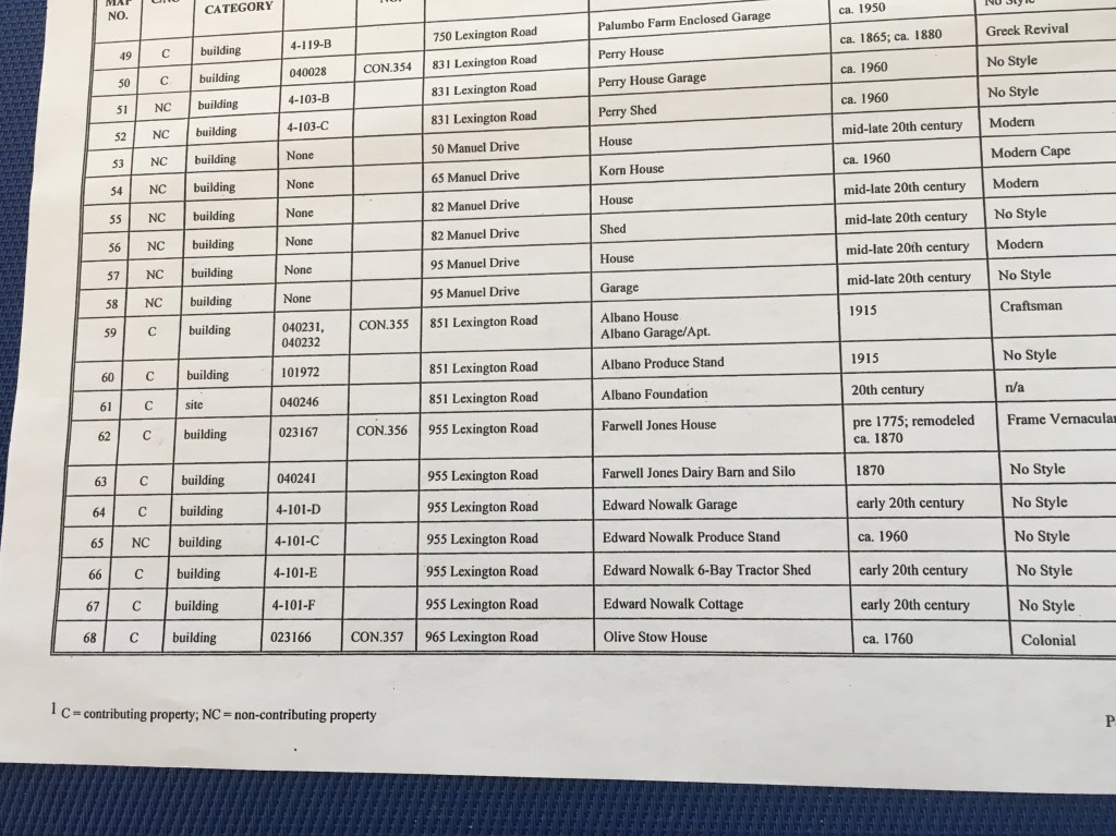
Architectural Description: #851/855 is a 1 ½ -story shingled, 3-bay cottage of ca. 1915-20, its lines today altered by a large shed dormer across the facade. The foundation of the main house is rubble; a 1-story east ell connects with a 2-story barn standing on a high base of rough-faced concrete block. The windows here are 6-over-1-sash in the house; 8-over-1 and 2-over-1-sash in the barn. There is a large-light glass and panel door at the main entry, and exposed rafter ends at the unboxed eaves.
Historical Narrative: #851/855, today called “Twin Ash Farm”, is significant as a surviving early-twentieth-century farmstead, complete with fields to the rear, and a well-preserved roadside stand. Today it is owned by the National Park Service.
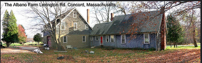
And there also, was a picture of the property that had stood on that land. Unfortunately, the quality of the picture is not great, but there was the little farmstand and it was surrounded by a large house to its left. “So, that’s what was there,” I thought to myself. Twin Ash Farm… a now name to this lonely, lovely little structure. But could I find out more?
Leslie and I continued our sleuthing and found documentation from the United States Department of the Interior – National Park Service, called the National Register of Historic Places Continuation Sheet, Property Name is Minute Man National Historical Park, Section 7, Page 18 about this property. It reads:
“One of the park’s few contributing twentieth-century buildings is the Albano House (map no. 59) at 851 Lexington Road (map no. 51). The building is set back approximately fifty feet from the street, within a landscape dotted with several mature trees and shrubs. Open farmland is located to the north. It is a one-and-one-half story, side-gable, Craftsman style building clad in wood shingles and set on a fieldstone foundation. A lower, one-and-one-half story, side-gable ell connects the east end of the main block to a large, one-and-a-half story, side-gable garage/apartment set on a high rusticated concrete block foundation. The south elevation of the attached garage/apartment includes a vehicular entrance set down a slope with a stone retaining wall. A centrally-located one-story one-bay, flat-roof entrance porch with slender, square posts is attached to the facade (south). A shed-roof dormer spans the south elevations of both the main block and the attached garage/apartment. Fenestration consists of single and paired, six-over-one, double-hung-sash windows set in simple wood surrounds. Other elements of the building include exposed rafter ends and two, exterior brick chimneys. To the northeast of the house are the stone remains of a barn which once stood on the site. The Albano Foundation (map no. 61) is approximately thirty feet by forty-five feet wide and is partially recessed below grade on the west, north and east sides. To the southeast of the house, set close to the road, stands a one-story, side-gable Produce Stand (map no. 60) sheathed in novelty siding and set on concrete blocks This small building features a one-story, shed-roof, full-facade porch with plain wood posts and lattice on the south elevation. Two long, rectangular windows flank the centrally-located entrance on the south elevation. The building’s east elevation includes a one-over-one, double-hung-sash window, flanked by slender, eight-light, rectangular windows.
And in the back of this resource, was a listing page of properties, towards whether it was contributing or non-contributing. And the Albano Produce Stand, built in 1915 was listed, along with other “produce stands” at 955 Lexington Road (Edward Nowalk Produce Stand – 1960) and at 1087 Lexington Road (D. Inferrara Farm Stand, ca. 1920s). Three farm stands in the stretch of about a half mile, all once active, now all empty.
So, now I had both a name of the farm stand, along with a family name. It really made this little farmstand come to life with this information. But I wanted more information, what was the history of this particular area and how did it get to this state? Time for more research.
From walking on the Battle Road trail, I had seen many signs about how this area was all farm land in 1775 and that the farmers also played a pivotal role in the April 19th battle. I knew from living in Concord for 26 years that there were some family farms that I frequented, such as Brigham Farm and Verrill Farm. Luckily, in my time at the library, I found a source that discussed the cultural history of this area, especially in the 1900s. (https://www.nps.gov/parkhistory/online_books/mima/clr.pdf) This history discussed how “The popularity of ‘motor touring’ provided an increasing customer base for the roadside stands. As an example of their profitability, a 1933 highway layout map (turnpike cut-off) depicts five roadside stands along the Battle Road within a one-fifth mile segment.” (p. 77). The ethnic backgrounds of the farmers also changed over this time frame and the percentage of people who farmed decreased. After World War II, there were more homes built in this area, along with the development of Hanscom Air Force Base and of Route 128.. The families who had been farmers in the earlier part of the century, continued to successfully farm their lands. In the late 1950s, there began to be talk about preserving the Battle Road area. In a 1968 follow-up to the strategic plan for Minuteman National Park, “the plan identified buildings and structures within the park boundary to be retained, removed, or demolished, and it explored the establishment of historic motor trails within the park. “ (p. 107). The National Park Service identified structures that were historic and structures that were non-historic. Among the non-historic structures were: “a veterinarian hospital, an automotive dealership garage, restaurants, residences, garages, barns, outbuildings, and farm stands.” (p. 108). However, agricultural buildings, that were kept were both the Albano and Norwalk farms.
From NPS report referenced above
According to this report, the Albano Farm was slated to not be demolished. But with the exception of the farm stand, the rest of it is not there any longer. What happened to the rest of the house that was described as standing in both of the earlier reports? The barn was described as a foundation, but the description and pictures of the house was pretty clear that there was a house on the property. Back to doing some internet research. And luckily, I found some information on the Concord Historical Commission’s annual reports. In 2009, this commission wrote: “We were also asked by the Massachusetts Historical Commission to comment on the proposed demolition of the Albano Farm on Lexington Rd. This property is owned by the National Park and, as such, required a Section 106 review prior to demolition. The Historical Commission agreed to the demolition of the farm, but asked that the small roadside farm stand remain to preserve the historic rhythm of small farm stands along that section of Lexington Road. The Park has agreed to this request.” (p.80)
https://concordma.gov/DocumentCenter/View/2506/Historical-Comm-PDF. This seems to indicate that the house was standing until somewhat recently. In the 2012 annual report, it states: “The Commission was delighted to discover this past fall that the small produce stand along Lexington Road has a new roof! The Historical Commission had requested that the National Park Service preserve the farm stand when the Albano farmhouse was slated for demolition several years ago due to severe deterioration; the stand contributes meaning to this historic byway. A thank you letter was sent to Superintendent Nancy Nelson for the Minute Man National Historic Park, who reports that they plan to make use of the stand for The Park’s apprentice farming program.” (pp 85-86),
https://www.concordma.gov/DocumentCenter/View/2320/Historic-Districts-Commission-PDF?bidId=.
While all this information was great, I still felt that I was missing a human connection to the story. I belong to a Facebook group about Concord, so I put out a post with a picture of the farmstand and asked people what they knew about the farm stand. I did receive a lot of comments on the request, although not all of them were relevant to my question. I learned that the house was torn down after the roof collapsed. They use to sell many things at the farm stand, but it hadn’t been active for many years. Another person replied how the Concord Historical Commission got the National Park Service to get it a new roof, but commented that it now needs body work. This person remarked that it was nice to have it on Lexington Road and that every now and again, pie sellers would use it to sell pies. Other people noted that it was nice to have a lot of farm stands within close proximity to one another, while another expressed concern that this farm stand could also be wiped out, leaving no trace of this part of Concord’s history. What did strike me through all the other different responses was that people who lived in this part of time, had a close connection to other families who farmed in this area. They shared stories of grandparents and recipes, and of their family homes, some that no longer exist. I have to admit, I lived in Concord during this time period where homes were being bought by the Park Service. But, the only story I remember specifically was when Willow Pond Kitchen, a local legend (that I had never been to), was being closed and demolished to make a parking area (that I always use when I am on the trail). I do remember a recent story about Palumbo Farm being closed, but other than that, I need to claim ignorance on this project. .
Still wanting to dig deeper to obtain more of a human connection, on Google, I found a Flickr account by a Mr. TGT that had an album called “Albano Cousins Reunion 2005”. (https://www.flickr.com/photos/mrtgt/albums/72157594176025103/with/52038967/) On that album were six pictures of the house and farm stand. I learned that Mr. TGT’s mother was born in a room above the garage/barn. The house looked similarly sided to the farmstand, and at that point, had the similarly peeling paint around the windows. Under one of the pictures, was a caption from Mr. TGT that said “My Grandfather’s farm @ Concord , MA

Mr. TGT’s Flickr Picture of His Family Farm
Federal Government has purchased property to become part of Battle of Lexington_Concord battlefield National Park. Also 3 homes to the left lived Louisa-May Alcott the author of Little Women.” And underneath that comment was another one that read: “My name is Joe Albano and my family also lived on that farm prior to 1927 my grandfather and his brother Sal were in business together .I remember as a young child going with my family to visit Uncle Sal and cousin louis. Please contact me I would like to share the history of the family and farm.” So, I did contact him, and even though the comment was nine years old, in a six-hour time frame, he did respond to my email and we set up a telephone conversation for the next day.
From Mr. TGT’s Flickr album
At 9:00 a.m., I called the number that Joe had left me and he immediately picked up. Before even going into his story, I want to thank him for making my pictures and the beginning of this story, really come to life. This 13 minute conversation brought light to the history of the farm and provided a human element to this story.
Joe’s grandfather Joseph and his brother Salvatore, bought the farm in the 1900s after arriving from Italy. The Albano brothers did not go through Ellis Island, they came right into Boston. The brother originally worked the farm together, but Joseph’s grandmother did not like being so far out in “the country” and so they moved to Newton, where they opened a store that sold fruits and vegetables. Sal stayed on the farm, raising his family there, along with raising vegetables such as carrots, peas, and tomatoes to sell at their farm stand. Sal’s son Louie, would eventually take over the farm. Joe remembers many fond childhood memories, visiting the farm. He recalls picking blueberries, swimming in a swimming hole that sat in the back field of the property that was always chilly as it was spring fed, and being given silver spoons, complete with the family initial, to go outside and dig. Joe also told about the many arrowheads that they found on the property. Many years later, Joe went up to visit Ana, Louie’s wife, who still lived on the farm. He asked if he could do some metal detecting. And in addition to the 1902 silver coins that he found he found those spoons. As he told me, “I am thankful to have those childhood memories.”
Louie, Sal’s son, took over the farm after his father had a stroke and was confined to a wheelchair. Joe stated that “Louie did a great job.” Louie also worked in the Agricultural Department and did a great job keeping the farm as a working farm. Joe recounts that his grandfather Joseph use to go up to the farm to see his brother, and instead of visiting with his brother, he use to go out and farm. Even though Joseph had moved away from the farm, he was still a “farmer at heart.” During our conversation, I also found out that the Albanos also owned land across the road. They dug an irrigation pond, which Joe says if you cross the road, follow the trail, you should still come to the pond. Additionally, Joe said there was also a small house behind the farm stand that use to house the seasonal migrant workers.
A surprise that I found out during our conversation, which is the picture of the house that I found, is not actually the original house that sat on the property and that Sal and Joseph bought. That original house, was struck by lightning during a “thunder-snow” storm in the late teens time frame and burned down. The house that was demolished by the National Park Service around 2009-2010 was to replace the house that was struck by lightning and destroyed. Joe said that it was around then that his grandmother had enough and they moved to Newton. As a result of the fire, Sal and later Louie, made sure that every building had a lightning rod on it. There had been one on the farmstand, but perhaps when the roof was redone in 2012, it was taken off of the farm stand. And yet another surprise was that the farm stand was featured in a Trailways Bus Commercial to commemorate the Bicentennial in 1976, that was shown nationally. Pretty cool that this little farm stand came to living rooms all over the United States.
From NPS publication
So, what happened to the farm? Louie died at age 62, leaving the farm to his wife Ana. From Town of Concord Property Records, (http://gis.vgsi.com/concordma/Parcel.aspx?pid=3410), the National Park Service bought the property for $185,000.00 on November 1, 1975, which confirms Joe’s statement that the family only received several hundred thousand dollars to sell the farm. Anna was allowed to live there for the rest of her natural life, although according to her obituary, it appears that she did move to Belmont later in her life. The family was allowed to keep 10 acres of land across the street, although I am thinking that after looking at the Massachusetts Interactive Property Maps (http://massgis.maps.arcgis.com/apps/OnePane/basicviewer/index.html?appid=47689963e7bb4007961676ad9fc56ae9), that perhaps the government now owns that as well.
Joe recalled that he had gone up and walked around the property after the government took control of the land. He said a park ranger asked him what he was doing. He told them that this was his family home at one time and that “they had broken their promise.” When the property was purchased, the Government agreed to maintain the houses and they didn’t. Joe said that inside the house was beautiful, it was full of mahogany wood and he didn’t like that the government let it deteriorate. The park rangers referred him to go the person in charge. He told her that the contract said that the government needed to maintain the properties. She said she knew that, but there wasn’t any money in the budget for these properties’ upkeep. So, as we know, the house deteriorated enough that it needed to be demolished. I could hear the bitterness in Joe’s voice as he told this story, but he also shared that he had so many wonderful stories of his family homestead and to me, it seemed like these memories for him were far more important than what happened to the house.
So, that is the story of this Forgotten Farmstand. It was not abandoned, in fact, it was much loved by members of the Albano Family. The Concord Historical Commission alerted the Park Service about the need for a new roof, so perhaps they will continue to be its advocate. On Route 2A in the 1950s, Joe said that “there was one farm after another, and it was like stepping into the past.” Perhaps, it is lucky that this piece of the past, the Albano Farm Stand still stands to remind us all of another time were life was full of multiple vegetable stands, children digging for treasure with silver spoons, and close knit families and neighbors, who many years later, still fondly recall the days of farms on the eastern end of Concord.
Waiting…what stories do other buildings in your community have to tell?